 On the tarmac at OAK — 7:31 pm Pacific.
According to the screen above the loading ramp door, Flight 2793 was underway for 6 minutes already when I began down the ramp. We had left at 7:20; on time. Not true, sorry to say. Here in 23-F, second row from the back, starboard window seat, I wait for a passel of passengers to load. In Row 18, a baby melts down in spectacular fashion. Poor child. Poor mom. And poor the rest of us. We sit. She accelerates.
It’s dark, so the view out the window won’t offer much distraction. Hopefully, this poor babe will cry herself to sleep, so some of the rest might nap also.
From OAK, we will fly north by northeast to GEG, much more north than east. The pilot says we are 1:26 from GEG — once we get airborne. Now we are moving. Backwards, but still. In anticipation, perhaps, the babe quiets. The gratitude in the cabin is palpable. Hopefully, it will keep the peace.
Time to power down.
10,400 feet — 7:46 pm Pacific. It’s safe to turn on large electronic devices, by whose judgment and why at 10,000 feet I have never determined. The babe sleeps. Screens light up all about the cabin. Southwest has free in-flight television this week.
It’s challenging to type with my elbows screwed to my ribs, but it can be done. The guy sitting next to me watching Fast and Loud on his I-Pad drops his right elbow off the dividing armrest. Gaining those two inches of advantage makes all the difference in the world.
Oakland and central California fall below and then behind. There are extra-large patches of jewels out there, but in the distance is black on black with an occasional topaz of mercury vapor light marking somebody’s far country yard. This reminds me that I am homeward bound.
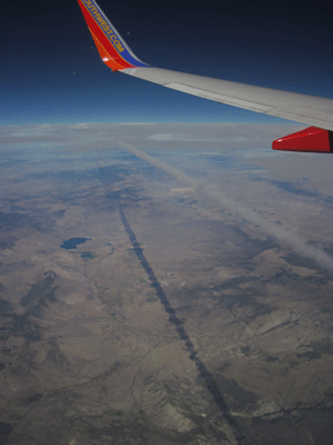
The geography challenge of today was our flight from ABQ to OAK. The sun hung off the port bow after takeoff, trending forward as we progressed, and I realized we weren’t on the azimuth I expected. We flew over a big river and then the southern end of a city that could only be Las Vegas, and I finally checked the rudimentary map in the in-flight magazine.
To my surprise, OAK is mostly west and a just bit north of ABQ, rather than mostly north, as I had assumed. Hmm. And ABQ is a heck of a lot farther from OAK than GEG. And, the line between ABQ and OAK goes right over Las Vegas. Back to the classroom, Compton, and take your map of the US with you.
It’s interesting how perceptions of topography gained from being earth-bound are corrected when we rise into the air.
It was with some poignancy that I watched Las Vegas slide under the wing, then Red Rock State Park at the foot of the orange escarpment of the Spring Range and finally, Charleston Village, the tiny, high-altitude last resort where I spent the first of the three craziest years of my life. It was living at Mount Charleston that I learned to appreciate the desert for its own unique beauty. It was living in Vegas that I confronted some personal monsters, managed to survive them and even slay a few.
I’ve been back to those neighborhoods since, but the only reason I might want to revisit those times would be to see if I could do better in round two. Lessons learned were ultimately beneficial, but they were damned expensive lessons.
The old saw about what doesn’t kill us might apply, but I’m not sure it’s always true. Maybe the experience made me wiser, and maybe wiser is stronger. Maybe. Sometimes we have the same problem with personal geography as we do with the physical.
“Where am I and how did I get here?” can be a daunting question if we can’t get enough elevation to acquire a view of our personal topography.
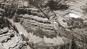
30,000 feet — 8:51 pm Pacific. We are over southeastern Oregon. I know this to be true because the fight tracker says so, and because there is not a single light to be seen below. Somewhere under us are the Steen Mountains, which are on my bucket list. I like places without lights; wild-ass places where it is a long way between plug-ins. Motorized access is OK, but it’s a damned fine thing to get out of the auto and walk away from the motor a long ways in one direction without coming to a road, fence, light, internal combustion machine, power pole or empty beer can. It doesn’t all have to be wilderness, as long as some of it is.
It’s better if that “some” is in big chunks, because that’s my version of elevation: distance achieved on foot from plug-ins, lights, ignition switches and empty beer cans. Maybe it’s time to go for a walk.
Sandy Compton is author of Side Trips From Cowboy: Addiction, Recovery and the Western Myth and several other books; available at Vanderfords, the Corner Book Store, Common Knowledge, sidetripsfromcowboy.com and bluecreekpress.com